Showing posts with label Delores River. Show all posts

Monday, March 12, 2018

Jeeping the Dolores River

By Jerry Smith


Today, Sunday 11, 2018, seven Grand Mesa Jeep Club members and two guests had a superb day of Jeeping.

After leaving Fruita, we headed for Cisco, UT and Fish Ford on the Colorado River.  This was the end of the trail from last week’s trip where we ran the back roads from 16 Road to Rabbit Valley along the BookCliffs.  From Rabbit Valley we followed the Kokopelli Trail (which Is the usual Rabbit Valley spring trip) and then stayed on it to the junction at Cisco.

Due to a late day and a freshly modified Jeep on its maiden voyage that had some bad gremlins, last week’s trip was shortened.  Today we finished that trip to Hwy 128 down near the Dome Plateau trailhead.  From there, we headed to Dewey Bridge for a trip across the Dolores River.

On the lower Dolores River Crossing

Jeeping across a river for many is a first-time accomplishment.  We broke some cherries today and didn’t stop at just one crossing.

Because the Dolores River was so low, we did the lower crossing and then proceeded to the upper crossing.

Entering the upper Dolores River crossing

The lower crossing is considerably shallower than the upper crossing.  It is also a more conventional ford in that you take a direct route across the river.

The upper ford is not conventional.  From the north side of the river (that we were on), you enter the river and go upstream an estimated 120 yards to the exit on the south side.  The water is fairly slow and always murky, so “reading” the water is not easy.

Entering the upper Dolores River crossing.

Entering the water the as the first in line is always with some trepidation.  You never know what obstacle might be lurking in the bottom of a murky body of water… especially moving water. 

Sandbars shift, muddy bottoms can have deep holes and be slick.  Rocks tend to find new places to bring you to an abrupt stop.  The first guy in the water is hoping none of those little “presents” exist. 

Entering the upper Dolores River crossing.

Lucky for me, no “presents” were encountered on the way upstream to the small rocky island just below the exit and road out to the main road.  Shortly Jeep number 2 entered the water and made for the island.  Not far behind were the others that braved the brown waters of the mighty Dolores River.
Soon we were all on the island and had a need to return to the north side, so I traveled down and found a spot to face the driver side window toward the others as they came downstream.  Some of the pictures here were taken from that position in the river.
Snoopy Rock

Entering the upper Dolores River crossing.
After returning to the north side, we headed for the Coates Creek crossing for lunch and some great conversation.   There, we also decided to return by way of Cow Creek and Snoopy Rock.  Most had never seen Snoopy Rock so this would be another first.


Cow Creek Canyon begins very docilely and gains difficulty and beauty as you go up the canyon.  Snoopy Rock is best seen from the east side.  From there you can see both ears, the nose, and an eye and the outline of the head sloping down to his back as he lays down.  The size of the whole thing is enormous, but you have to be there to understand.

Entering the upper Dolores River crossing.

Not long past Snoopy, the trail becomes increasingly difficult.  There are steep climbs that gyrate your vehicle causing tires to lose traction.  Here, you may still crawl the trail in 2wd, but you will need a very flexible suspension and good momentum.  Otherwise, lockers or 4wd are a real blessing.

There are large granite-like boulders that protrude from the road surface and other places that have a white granite-like rock that has large quantities of mica that create flashes of light that make you wonder what is ahead.

Entering the upper Dolores River crossing.
The cliffs on the north side of the canyon rise in varying outcroppings that make your imagination wander to out-of-the-world realms.  Some of the small canyons in those cliffs make you wonder where they go and “how can I go there?”

Upon topping the trail we soon come to the road normally taken from Glade Park to Gateway.  This is a popular summer trail run.  There are some options along with it that can enhance the day of Jeeping into a “Wow”-like trip.  One of the favorites is to drive down Lost Horse Creek to the junction with Granite Creek.

On the island in the Dolores River

 The road down Granite Creek Canyon is often overgrown with brush and has some light duty obstacles, but the deep canyon walls are spectacular.  The tops are a craggy rock formation that hold threatening possibilities of giant rock falls if you sneeze too hard.  You also cross the Colorado/Utah border along the way.  Sightings of wild turkeys and bears are fairly common.

The way out of the Granite Creek Canyon is a steep shelf road that once had dozens of well placed large rocks that caused folks dread of driving this road.  The BLM did their 10 to 15 year maintenance in 2017 so those rocks were dozed over the steep mountainside.  As the years go by, they will be replaced, so not all is lost.  Good challenges are hard enough to come by without the land management ruining things.

People think I’m nuts when I complain that the USFS or BLM actually maintain a Jeep trail.  I would rather the users maintain what actually needs maintenance to OUR standards than to have a perfectly good Jeep trail butchered by a man on a bulldozer who doesn’t care.  Of course “our” standards must meet their minimums, but basically, we only want a “passable” 4-wheel drive trail, not some highway.

Special Jeep trails with good obstacles are treasures that aren’t found just anywhere.  I am thinking of creating more obstacles on a trail or two that have diminished in difficulty since I reopened them years ago.  Some of us enjoy a tough trail that doesn’t stray toward the extreme but scares the pants off of others.

Even today’s river crossing raises the pulse of most until the first in line shows it can be done.  I could see the doubt in quite a few eyes before I dove in and ran that second crossing today.  BTW, I have driven that crossing with about 20” deeper water.  Today, my front bumper barely got wet.  In other crossings, the water was up on the hood and fenders.


Any way you do it, a good day of Jeeping is better than any other I can think of, so go out on your next opportunity and MAKE IT an unforgettable day.

Monday, May 22, 2017

The Calamity Mesa Loop - 2017

The Calamity Mesa Loop - 2017

by Jerry Smith


Calamity Mesa is in a remote part of western Colorado near the little town of Gateway.  This one hitch post town has a small school, a volunteer fire station, and one convenience store that dominates town business unless you count the expensive Gateway Canyons Resort.

Calamity Mesa has a rich history.  Most of the riches revolve around the uranium found deep in the ground, but other riches can be found on the surface.

From the mesa top, some of the views are like nowhere else. On a clear day to the south, the San Juan Mountains and Lone Cone Mountain stand covered with bright white snow.  Shift your eyes to the west and the Sewemup Mesa Wilderness Study Area will dominate your view.

Lone Cone Mountain is about 50-miles south


With no mention of under what conditions, this warning is for the road to Calamity Mesa.

Sewemup (Sew-em-up) Mesa has a rich history of its own.  Cattle rustlers once took their stolen herds into Sinbad Valley where they surgically removed the brands, sew-em-uped the wound, and later rebranded the animal.

Above Sewemup Mesa are the snowy tops of the La Sal Mountains.  Just to the right of Sewemup, the Salt Creek canyon winds its way up into Sinbad Valley.  Below your feet at the “lunch with a view”, the dark red Blue Creek Gorge dumps its stream into the larger Delores River. 

The La Sal Mountains have an anomaly in the spring.  A giant shark with his mouth open faces east.
To the north, there is Cone Mountain and the Sky Mesa Ranch.  Then Flat Top Mesa and Tenderfoot Mesa melt into Maverick Mesa. 

Saturday and Sunday, May 20&21, Calamity Mesa saw several of the Grand Mesa Jeep Club in trail maintenance mode.  Saturday we ran the Calamity Airstrip trail and the last 2/3s of the big loop.  Sunday, the entire Calamity Mesa Loop was run.

This is the confluence of Blue Creek and the Delores River
There are three major trails on Calamity Mesa.  The Calamity Mesa Loop is about a 19-mile loop with 12-named obstacles.  The Airstrip trail is on the mesa top where the views are incredible.  The third loop is a shorter loop with a small mining camp still standing.

The Calamity Mesa Loop was closed by Mother Nature for a minimum of 25 years… long enough for a Pinyon Pine to grow to about 5” at the butt in the middle of the road with no room to go around.

The Airstrip trail received limited brush cutting but will require more in the future.  Some of the oak brush that once covered the road has begun to regrow.  The day was near perfect for sightseeing with all the rain and snow we’d had.  The air was mostly clear and the San Juan Mountains and Lone Cone were looking cold in their white top hats.  The same could be said of the La Sal Mountains.

The Airstrip trail is reverting to an oak brush forest.
Saturday was largely uneventful compared to the Sunday trip.  Sunday began like any normal Jeep trip, but that didn’t last long.

Upon reaching the Gatekeeper obstacle, it was obvious that this winter had been very tough on the trail.  Serious erosion and the havoc it causes was apparent right from the start.  That is nothing new on Calamity Mesa. 

Many question the sanity of entering the Gatekeeper Wash
But when the trip leader sets off to show the rest of the group the line going down the rocky wash only to become stuck on the two large rocks in the bottom of the wash, things deteriorate.  When the rear axle rubbed on the rocks, rear axle traction became substantially reduced --- in two-wheel drive. 

Jumping out to assess the problem, I noticed there were no scratch marks under the front tires like there should have been.  Having been in 4-low, that meant the front wasn’t assisting the rear.  A quick turn on the front hubs and we pulled right up on the road.  Not much of a “stuck” compared with what was to come.

With the Gatekeeper behind us, the “Narrows” is the immediate next obstacle.  The wash that makes up the Gatekeeper continues down along the right side of the trail in a deep ditch with very steep sides.  This ditch cuts through a bentonite ridge and the trail has eroded away to barely the width of the average Jeep.  Bentonite is slick when dry.  When wet, forget it!!

The left side of the road is a steep bentonite hillside that one does not want to slip off onto and the narrow trail is crowned so much, a small-tired rig leaves an imprint where the differential drags.  One error in driving, either way, WILL result in a rollover.  We all made it safely across “The Narrows”. 

Further down the trail, we came to “Gyration Wash”.  Here again, serious erosion had changed the character of the obstacle.  At the beginning of the obstacle, you cross a deep wash diagonally that will require some serious articulation.  The water had cut a new, deep channel parallel to a fallen tree in the narrow wash bottom next to a steep off-camber stretch of trail.  Going into that new channel would have been bad and the traction on the off-camber trail tended to slide you toward it.

Once past that part of the obstacle, large rocks greet you in the wash.  In years past, that ended in a rocky waterfall with about a two-foot drop.  Some of the rocks were now further down the trail leaving a new obstacle to learn.  With a little spotting, everyone got through unscathed.

The next few miles have been relatively easy in the past.  Today, there were some new rockfalls that eventually got one of our group in trouble.  The first three vehicles were able to sneak around a large rock in the middle of the trail. Number four… not so much.  The “sneak” required you to get dangerously close to the lower side of the trail. 

Upon returning to the scene of the accident, it was clear that the people planning the extraction with a tow strap were about to make the situation worse, so we moved on to plan-B. 

After pointing Happy Trails toward a tree up the uphill, we ran the winch line through a snatch block and back to the Jeep off the side of the road.  With minimum trouble, we were back on the trail and headed for the “lunch-with-a-view”.

After the lunch, we made our way to some of the more difficult obstacles.  Most went well, but then we got to “Hogback”.  The entrance to Hogback has changed dramatically.  The wash that cuts diagonally across the trail is much deeper and ugly looking.  We all managed to get through the crossing and upon the rocky, narrow Hog’s back. 

"Rocket Man" showing why the name
"Hogback" with some showing off


Some did it with a little show by lifting the right front tire.  Then came “Rocket Man” in his white TJ.  His right front got some significant air time.

Once upon the top, your line choosing is critical or you become “turtled” very easily.  All the Jeeps managed to negotiate the tough obstacle just fine.  The FJ Cruiser with its typical limited articulation slipped off of one of the rocks and went laterally to the driver’s side.  So the second winch line came out to save the day.

Proper line choosing is critical on "Hogback"
In all fairness to the FJ, a Jeep had the same “calamity” on Saturday.  A short winch pull later he was on his way.  We hated to use the pristine wound virgin winch cable, but that's what a winch is for.

We broke in the winch and recovered the FJ
It’s been a long time since we needed to pull cable on the Calamity Mesa Loop.  Maybe we have been doing it all wrong.  Sometimes a little erosion can be a Jeepers friend.

Our next problem came at the “Overnight Wash” obstacle.  In past years, this wash has been a major problem.  Literal tons of rocks have been placed in the lower wash to keep the trail passable.  Every couple of years, more rocks are needed as they get washed downstream.  Some of those rocks have weighed hundreds of pounds and required a winch to move them.

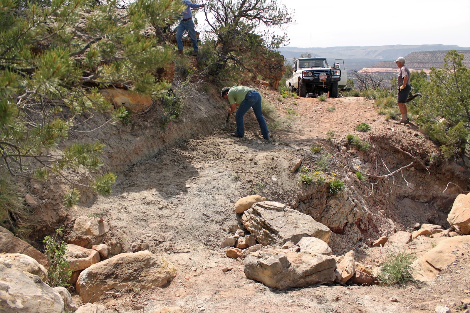
The crew moved several new rocks from the upper wash into the lower wash to both slow the water and to beef up the lower bank of the road.  The roadside was becoming unstable and dangerous.  We like a difficult trail but draw the line at dangerous.

The next obstacle is “Tippy Rock”.  It’s a fairly large rock in the middle of the trail.  Over the years, people have stacked rocks to make it easier to crawl over.  The first few years, you had to go up around the rock on the high-side requiring an extreme off-camber condition.

Some took the rock and others went around.  Then came the FJ again.  We thought it would crawl the rock with no trouble, but that was poor planning.  But after a couple of false tries, the FJ showed we were right.
"Tippy Rock makes a suspension work hard

Getting on "Tippy Rock" is easy, getting off... not so much
The last of the named obstacles is “The Squeeze”.  On the very side of the trail is an old Utah Juniper tree.  In the middle of the road is a substantial rock/boulder.  The distance between them just barely allows a JK width vehicle passage. (We do NOT allow full-size vehicles on this trail)

"The Squeeze" leaves little room for error
There are other obstacles and some narrow shelf road to negotiate along the trail.  Some of the shelf road has caused some to get out and walk. 

If a 19-mile loop road with some significant obstacles along the way sounds like your kind of trail, get signed up for the annual Grand Mesa Jeep Club’s “Rock Junction” event.  We have this and a couple other trails that are right on your “wanted” list.

One last thing needs to be addressed.  Yogi Berra said it first, but any GREAT Jeeper lives it;  “When you come to a fork in the road… take it!”  That is where adventure often awaits.

Widening the trail has been necessary more than once

This is another look at "Overnight Wash" from long ago

Note the large rocks on the right.  They have washed away.


This is the stump of the tree in the middle of the road when we reopened the Calamity Mesa Loop
"Mike's Rock" will take mirrors or paint if you're not careful

Happy Trails on "Twisted Drop"