Showing posts with label Calamity Airstrip trail. Show all posts

Monday, May 27, 2019

Gaining Jeep Trail Access


Gaining Jeep Trail Access

By Jerry Smith


Not long after we moved to Grand Junction, Colorado, I began exploring area Jeep trails in my ’73 CJ5 (Old Blue).  As a traveling salesman at the time, my time off from work was extremely rare and valuable.

New to Grand Junction (GJT) and seldom home, I had nearly no local friends to find out about the area.  The answer was to take a map of the area and draw a 50-mile radius circle around GJT.  Driving ALL Jeep trails within that circle was now a goal.

It took till about 2009 to be able to say I accomplished that goal and then a little, but it’s safe to say that at one time or another, I have traveled 98% of all Jeep trails in that circle... and believe me, there ARE many.

Image may contain: mountain, grass, sky, plant, outdoor and nature
Happy Trails leading on Sheep Cr.
During that time frame, we (Old Blue, Happy Trails [my ’06 Rubicon] and I) managed to find some trails in need of some TLC.  Trails that Mother Nature had closed for one reason or another were not to be ignored like most people do.  In my younger and healthier years, when an impassable obstacle presented on a Jeep trail, we simply removed or repaired it. 

To me, THAT is just part of the Jeeping experience.  You see a problem and remedy it.  Overcoming obstacles is part of the fun.  Opening a new trail or reopening an old trail is something few of us ever have the pleasure of… and yes, it definitely is a pleasure.  But you must find the opportunity to do it!

Exploring every sidetrack is the way of finding old and new opportunities.  They are out there.  If nothing else, look at the trails that have been closed by land management.  There ARE possibilities of reopening them if you get creative and solve the problems that caused the closure in the first place.

The first trail with that kind of show-stopping problems we worked on was Pace Lake.  Part of the trail goes through an old burn and several of the old dead snags had blown down over the road.  The tracks in the trail were common.  People would drive up to the first tree and turn around.  Between a hand saw and the winch, we moved several trees to get to the first main obstacle.
Off-Camber on Pace Lake
This turned out to be a 3-foot wide gash snaking its way down the road about 3-feet deep and 75-yards long.  Trying to straddle the trench only resulted in the first body damage to Happy Trails.  Now it was a working Jeep… not a pleasure Jeep. (I prefer working Jeeps)


Before I worked on the ditch, there was a short walk up the trail to make sure all that work would be worth the effort.  From that walk, I knew there was a big rock fall not far up the trail, but it looked like something we could get around.

So… for the next few hours, I threw everything I could find in that ditch.  Trees, limbs, rocks, dirt, and sweat mostly filled it in.  There was some REAL satisfaction when we drove the full length of that thing!
On the Pace Lake trail
At the big rock fall, taking a turn around the first kitchen table-size rock, we started to climb the high-side bank of the road to evade another large boulder.  That would have worked well except the rear slid over into the boulder and broke the plastic wheel cap on the right rear. (the second damage to Happy Trails)

After a few more trees, we finally reached the top and end of the Pace Lake trail.  The lake is on the Utah side of the border, which is on the wrong side of the fence to the JB Ranch.  The JB Ranch has an agreement with the Fish and Wildlife as a private hunting preserve and they are adamant about trespassers.

** As a side note, we are working with the USFS, BLM, and a private landowner to connect the top of the Pace Lake trail to another trail to make a loop trail.  This is going through the Manti-La Sal Forest Planning presently. See – opportunities!!  ** 

Next came the Calamity Mesa Loop Trail.  This one had been closed for an estimated 25+ years.  Calamity Mesa took some help from two Jeep Clubs to officially open the first half of the trail.  The second half was mostly just myself again.  The Calamity Mesa Loop Trail is a 19-mile loop from the trailhead to the end.  If you count the mile from the end to the trailhead, it’s 20-miles.

This stump was a tree growing in the middle of the road showing how long the trail had been closed.
Calamity Mesa also has one other smaller 5-mile loop and another trail on top of the mesa from the airstrip to an intersection with the big loop that we reopened.  There is a library full of uranium mining history in the area and some drop dead beautiful scenery.
The Calamity Mesa Loop trail has 10-named obstacles to add some excitement.


Next, we found Flat Top Mesa closed due to two monstrous rocks blocking the road.  This one took some extreme nerve to drive past the second rock.  Your paint was less than 1” from being removed by it as you passed it.  Those were some intense moments the first few times we drove this trail alone.  
That rock on the right is close to the paint.
People have elected to pass driving their pretty paint jobs through this on the two trips we have lead up this trail.

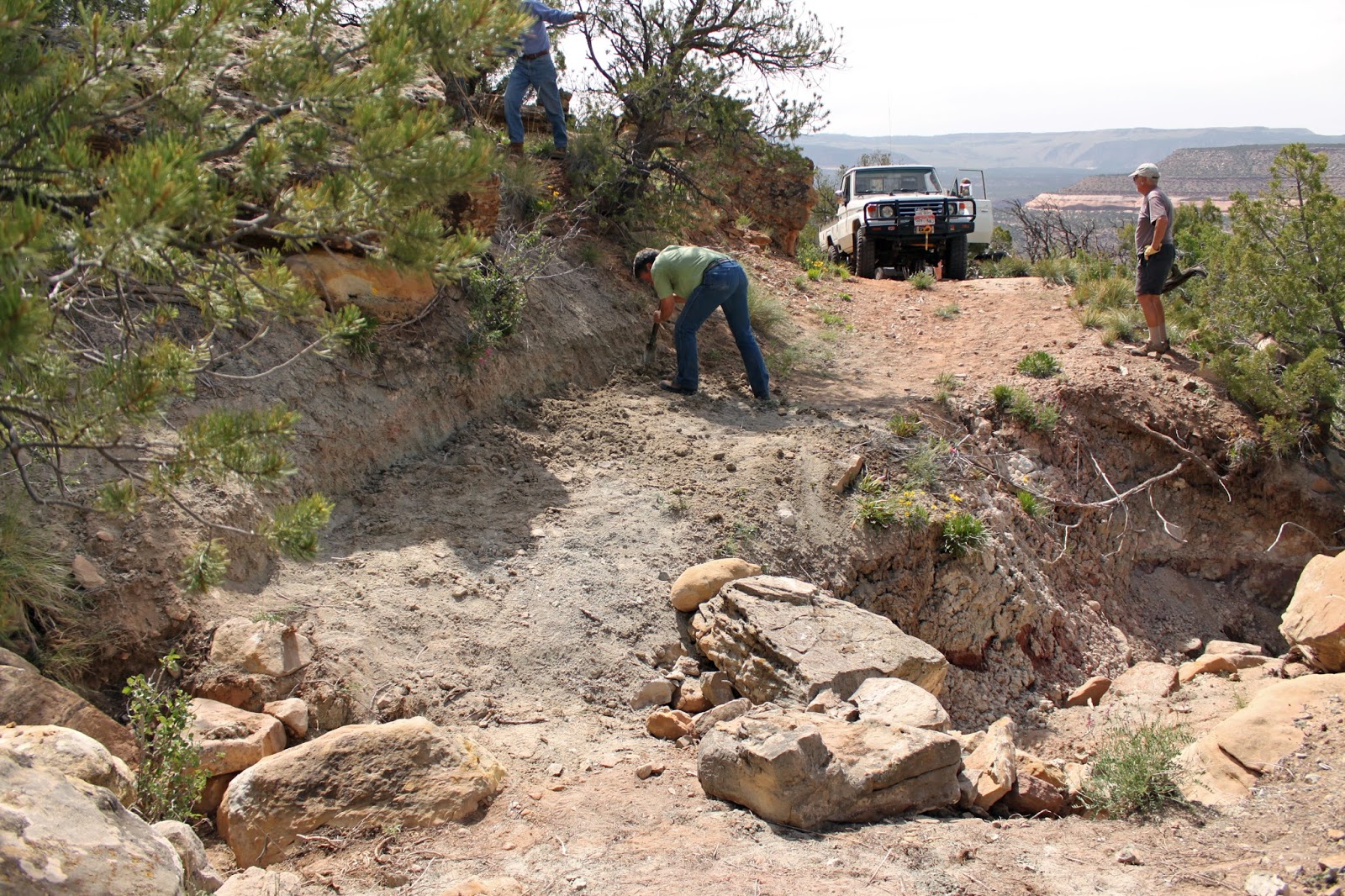
Next was the Coon Hollow Jeep Trail.  This was marked on BLM maps as a “Jeep trail”, but it had not been used by full-size vehicles for many years and had grown in tight to ATV width with four-foot tall sagebrush and had some deep washes to deal with.  It took a lot of work to reopen Coon Hollow.

This wash was "washed out" by a flash flood
 When we did the work, the area was still managed as “open” to cross country travel, so what we did was legal for you who are touchy about such things.  We created bypasses of two washouts of the trail and trimmed and trampled miles of the tall sagebrush to reestablish a full-width trail again.

Coon Hollow has become another “highlight” trail for our annual Rock Junction event.

South Beaver Mesa was next.  This one is a steep, narrow, heavily eroded shelf road down to an old cowboy camp.  The trail is a great Jeep experience for seasoned drivers.  Others may find it frightening.
A dugout at the Cowboy Camp on So. Beaver Mesa
In 2018 I was contacted by the Paonia Forest Service office and asked if we would come and widen a Jeep trail by cutting miles of heavy overgrown brush back.  It took two trips, but we got it done.
Trimming the Lone Cabin Trail
Just counting these trails, that is over 100-miles of Jeep trails that we have been responsible for reopening.  Some we must work on nearly every year just to maintain them.  Sheep Creek is a prime example.

In the fall of 2018, a nasty storm hit the upper region of the Sheep Creek Jeep Trail.  It brought down tons of debris off the mountainside onto the road and severely eroded the road surface.  This is a common occurrence on Sheep Creek.  Once or twice each year this trail is subject to closure by Mother Nature. 

Sometime during the winter of ‘08/’09, more storm damage added to the previous carnage and added a humungous rock (15’ tall and the width of the road) to our problems.  Sheep Creek is part of one of the favorite trips we lead people on for our Rock Junction event.  Having it closed was not going to make some people happy.
This rock blocked Sheep Creek
Because of all the damage and the huge rock, we met with the BLM to discuss what could be done to reopen the trail “legally”.  Our club has a very strong working relationship with the local BLM.  They gave us some parameters to work within to open the trail.

Sunday, May 19th began as a workday to reopen the Sheep Creek trail.  We started out with a good-size crew of eager beavers ready to move the world if necessary.  In reality, they turned out to be a worthless bunch that never moved a rock all day.  Not even one shovel full of dirt turned.  It wasn’t their entire fault, though. 

While airing down at the Sheep Creek trailhead, a phone call from Keri informed us that a crawler tractor had already been up the trail and had removed all obstacles.  Work party disaster!

With that news, we lost Jeff and his buggy.  The rest of us decided to run the trail through to Glade Park.  On our way to the top, over the radio comes word that Luke had ridden through Granite Creek where the word is there are “rock falls” near the “homestead”.

After a brief stop at the cabin near the top of the Sheep Creek trail, Roger’s freshly “repaired” LS powered JKU shot another code and became questionable, so the Bartons turned around with Dick following and left the mountain (we hope).

Topping the trail, we elected to head for a meeting with Keri somewhere along the trail toward Glade Park.  She couldn’t explain her location, so we were on a search and find mission.  On the radio, we were still hearing bits and pieces of what had been found down on Granite Creek.  The broken radio reception didn’t sound all that bad, so we did a quick turnaround and headed down Lost Horse Canyon on the way to Granite Creek Canyon.

After about 8-miles of travel, we stopped at the “homestead” and glassed a pickup that could be seen on the shelf road exit from the canyon bottom.  Even with drone flyover pictures, the overall predicament with the truck could not be determined, so up the road we went.

Just a short walk around a corner from the pickup was a serious rockfall blocking forward progress.  A quick look and some thoughts about it made me think we “could” move the big rocks enough to pass, but taking the walk around the corner made the effort fade into oblivion.  Not only was there another large rock partially blocking the road, but also a disabled pickup with unbelievable body damage and what appeared to be a broken front axle sat smack in the middle of the road.  Game over!

Back out through Granite Creek Canyon and Lost Horse Canyon to the road to Glade Park.

Overall, it was a good (long) day of Jeeping.  Many in the group saw some new country and trails they had never traveled, so all was not lost.  One of the Rock Junction favorite trails is again useable and we only had one and a half casualties.  I forgot to mention that Dick aired down two tires TOTALLY.  Whoops!!

This should give you some ideas of what can be done for motorized trail access “IF” someone takes the lead and follows through.  Of course, having support from other people makes this happen easier, but that all-important “point man” is VITAL to things like this!  Are YOU that person?

One last thing… always remember when you come to a fork in the road, Yogi said; “Take it!”  That is the first step to finding opportunities.

Monday, May 22, 2017

The Calamity Mesa Loop - 2017

The Calamity Mesa Loop - 2017

by Jerry Smith


Calamity Mesa is in a remote part of western Colorado near the little town of Gateway.  This one hitch post town has a small school, a volunteer fire station, and one convenience store that dominates town business unless you count the expensive Gateway Canyons Resort.

Calamity Mesa has a rich history.  Most of the riches revolve around the uranium found deep in the ground, but other riches can be found on the surface.

From the mesa top, some of the views are like nowhere else. On a clear day to the south, the San Juan Mountains and Lone Cone Mountain stand covered with bright white snow.  Shift your eyes to the west and the Sewemup Mesa Wilderness Study Area will dominate your view.

Lone Cone Mountain is about 50-miles south


With no mention of under what conditions, this warning is for the road to Calamity Mesa.

Sewemup (Sew-em-up) Mesa has a rich history of its own.  Cattle rustlers once took their stolen herds into Sinbad Valley where they surgically removed the brands, sew-em-uped the wound, and later rebranded the animal.

Above Sewemup Mesa are the snowy tops of the La Sal Mountains.  Just to the right of Sewemup, the Salt Creek canyon winds its way up into Sinbad Valley.  Below your feet at the “lunch with a view”, the dark red Blue Creek Gorge dumps its stream into the larger Delores River. 

The La Sal Mountains have an anomaly in the spring.  A giant shark with his mouth open faces east.
To the north, there is Cone Mountain and the Sky Mesa Ranch.  Then Flat Top Mesa and Tenderfoot Mesa melt into Maverick Mesa. 

Saturday and Sunday, May 20&21, Calamity Mesa saw several of the Grand Mesa Jeep Club in trail maintenance mode.  Saturday we ran the Calamity Airstrip trail and the last 2/3s of the big loop.  Sunday, the entire Calamity Mesa Loop was run.

This is the confluence of Blue Creek and the Delores River
There are three major trails on Calamity Mesa.  The Calamity Mesa Loop is about a 19-mile loop with 12-named obstacles.  The Airstrip trail is on the mesa top where the views are incredible.  The third loop is a shorter loop with a small mining camp still standing.

The Calamity Mesa Loop was closed by Mother Nature for a minimum of 25 years… long enough for a Pinyon Pine to grow to about 5” at the butt in the middle of the road with no room to go around.

The Airstrip trail received limited brush cutting but will require more in the future.  Some of the oak brush that once covered the road has begun to regrow.  The day was near perfect for sightseeing with all the rain and snow we’d had.  The air was mostly clear and the San Juan Mountains and Lone Cone were looking cold in their white top hats.  The same could be said of the La Sal Mountains.

The Airstrip trail is reverting to an oak brush forest.
Saturday was largely uneventful compared to the Sunday trip.  Sunday began like any normal Jeep trip, but that didn’t last long.

Upon reaching the Gatekeeper obstacle, it was obvious that this winter had been very tough on the trail.  Serious erosion and the havoc it causes was apparent right from the start.  That is nothing new on Calamity Mesa. 

Many question the sanity of entering the Gatekeeper Wash
But when the trip leader sets off to show the rest of the group the line going down the rocky wash only to become stuck on the two large rocks in the bottom of the wash, things deteriorate.  When the rear axle rubbed on the rocks, rear axle traction became substantially reduced --- in two-wheel drive. 

Jumping out to assess the problem, I noticed there were no scratch marks under the front tires like there should have been.  Having been in 4-low, that meant the front wasn’t assisting the rear.  A quick turn on the front hubs and we pulled right up on the road.  Not much of a “stuck” compared with what was to come.

With the Gatekeeper behind us, the “Narrows” is the immediate next obstacle.  The wash that makes up the Gatekeeper continues down along the right side of the trail in a deep ditch with very steep sides.  This ditch cuts through a bentonite ridge and the trail has eroded away to barely the width of the average Jeep.  Bentonite is slick when dry.  When wet, forget it!!

The left side of the road is a steep bentonite hillside that one does not want to slip off onto and the narrow trail is crowned so much, a small-tired rig leaves an imprint where the differential drags.  One error in driving, either way, WILL result in a rollover.  We all made it safely across “The Narrows”. 

Further down the trail, we came to “Gyration Wash”.  Here again, serious erosion had changed the character of the obstacle.  At the beginning of the obstacle, you cross a deep wash diagonally that will require some serious articulation.  The water had cut a new, deep channel parallel to a fallen tree in the narrow wash bottom next to a steep off-camber stretch of trail.  Going into that new channel would have been bad and the traction on the off-camber trail tended to slide you toward it.

Once past that part of the obstacle, large rocks greet you in the wash.  In years past, that ended in a rocky waterfall with about a two-foot drop.  Some of the rocks were now further down the trail leaving a new obstacle to learn.  With a little spotting, everyone got through unscathed.

The next few miles have been relatively easy in the past.  Today, there were some new rockfalls that eventually got one of our group in trouble.  The first three vehicles were able to sneak around a large rock in the middle of the trail. Number four… not so much.  The “sneak” required you to get dangerously close to the lower side of the trail. 

Upon returning to the scene of the accident, it was clear that the people planning the extraction with a tow strap were about to make the situation worse, so we moved on to plan-B. 

After pointing Happy Trails toward a tree up the uphill, we ran the winch line through a snatch block and back to the Jeep off the side of the road.  With minimum trouble, we were back on the trail and headed for the “lunch-with-a-view”.

After the lunch, we made our way to some of the more difficult obstacles.  Most went well, but then we got to “Hogback”.  The entrance to Hogback has changed dramatically.  The wash that cuts diagonally across the trail is much deeper and ugly looking.  We all managed to get through the crossing and upon the rocky, narrow Hog’s back. 

"Rocket Man" showing why the name
"Hogback" with some showing off


Some did it with a little show by lifting the right front tire.  Then came “Rocket Man” in his white TJ.  His right front got some significant air time.

Once upon the top, your line choosing is critical or you become “turtled” very easily.  All the Jeeps managed to negotiate the tough obstacle just fine.  The FJ Cruiser with its typical limited articulation slipped off of one of the rocks and went laterally to the driver’s side.  So the second winch line came out to save the day.

Proper line choosing is critical on "Hogback"
In all fairness to the FJ, a Jeep had the same “calamity” on Saturday.  A short winch pull later he was on his way.  We hated to use the pristine wound virgin winch cable, but that's what a winch is for.

We broke in the winch and recovered the FJ
It’s been a long time since we needed to pull cable on the Calamity Mesa Loop.  Maybe we have been doing it all wrong.  Sometimes a little erosion can be a Jeepers friend.

Our next problem came at the “Overnight Wash” obstacle.  In past years, this wash has been a major problem.  Literal tons of rocks have been placed in the lower wash to keep the trail passable.  Every couple of years, more rocks are needed as they get washed downstream.  Some of those rocks have weighed hundreds of pounds and required a winch to move them.

The crew moved several new rocks from the upper wash into the lower wash to both slow the water and to beef up the lower bank of the road.  The roadside was becoming unstable and dangerous.  We like a difficult trail but draw the line at dangerous.

The next obstacle is “Tippy Rock”.  It’s a fairly large rock in the middle of the trail.  Over the years, people have stacked rocks to make it easier to crawl over.  The first few years, you had to go up around the rock on the high-side requiring an extreme off-camber condition.

Some took the rock and others went around.  Then came the FJ again.  We thought it would crawl the rock with no trouble, but that was poor planning.  But after a couple of false tries, the FJ showed we were right.
"Tippy Rock makes a suspension work hard

Getting on "Tippy Rock" is easy, getting off... not so much
The last of the named obstacles is “The Squeeze”.  On the very side of the trail is an old Utah Juniper tree.  In the middle of the road is a substantial rock/boulder.  The distance between them just barely allows a JK width vehicle passage. (We do NOT allow full-size vehicles on this trail)

"The Squeeze" leaves little room for error
There are other obstacles and some narrow shelf road to negotiate along the trail.  Some of the shelf road has caused some to get out and walk. 

If a 19-mile loop road with some significant obstacles along the way sounds like your kind of trail, get signed up for the annual Grand Mesa Jeep Club’s “Rock Junction” event.  We have this and a couple other trails that are right on your “wanted” list.

One last thing needs to be addressed.  Yogi Berra said it first, but any GREAT Jeeper lives it;  “When you come to a fork in the road… take it!”  That is where adventure often awaits.

Widening the trail has been necessary more than once

This is another look at "Overnight Wash" from long ago

Note the large rocks on the right.  They have washed away.


This is the stump of the tree in the middle of the road when we reopened the Calamity Mesa Loop
"Mike's Rock" will take mirrors or paint if you're not careful

Happy Trails on "Twisted Drop"