Delores Overlook and Others
By Jerry Smith
Yesterday, March 19, 2017, the majority of Grand Mesa Jeep Club participants headed for the Top of the World Jeep trail of Moab fame. Thirteen rigs left Fruita and assembled at the Dewey Bridge turn-off to air down. A 14th joined us there. Several other rigs passed by on their way to the same destination as trail preparations were made.
 |
| The Delores River from Delores Overlook |
I had already informed trip leader Todd that I would not be doing Top of the World but would follow them to the trailhead, as that was on my way to the Delores Overlook trail and other area trails. Just before leaving the staging area, Tom asked if I would like some company, so Tom and Connie tagged along on one of my many exploration forays into the Great American BackCountry.
The short trip to the trailhead was one of severe dust. Judging by the way the thick, yellowish cloud hung in the air over the freshly bladed road, wind, or lack of it, would be a problem today. The line of intelligent Jeepers became strung out over great distances, the others, well… let’s just say they will need a new air cleaner.
 |
| The Delores River from Delores Overlook |
As Tom and I passed the others, it was clear that their dust problems would be greatly lessened because their trail speed would be cut by about twenty miles per hour. The Red Rock 4-Wheelers rate the Top of the World trail as a 6 in their Easter Jeep Safari paper. When you drive the upper loop in a clockwise direction, you may think you’re on a 7 or 7+.
We, on the other hand, continued on the Entrada Road creating billowing clouds of choking dust. Except when stopping to pick up some O.P.T., I seldom saw Tom in the mirror. (O.P.T. is; Other People’s Trash). We did communicate on the CB so that there was some idea of where the other was.
 |
| The Sleeping Camel |
Around 13-miles into the trip, we came to the first of two 4-way intersections. Continuing straight would eventually take you to the famous Rose Garden Hill. I had already descended Rose Garden twice this year. As obstacles go in the last few years, Rose Garden has gone from difficult to extremely difficult. On the first trip DOWN this year, we had to winch one vehicle that became hung up on a ledge. With the large rocks and ledges and all the loose rock and sand, ascending Rose Garden looks to be close to a Hammers type obstacle. You get a good mental and physical workout going DOWN.
The road to the left would take us out to the Delores River Overlook. This is a trail with some light challenges at first. Once you reach the mesa top below, the trail almost challenges you to see how fast you can drive.
The “overlook” is a spectacular vision. You are standing at the intersection of the Delores River and Cottonwood Canyon, only hundreds of feet above this eye feast. Today, the river was running a chocolate color liquid that contrasted with the red and cream colored cliffs reaching skyward from the milky waters.
Directly across the river is Steamboat Mesa. Steamboat is a massive flat top mountain setting on two sets of high vertical cliffs. From the top, the 360-degree views are just fabulous. If you are a bush pilot, you may land on the airstrip on top.
 |
| The Delores Overlook from a distance |
 |
| Steamboat Mesa |
The deep gorge of the Delores River is a sight all by its lonesome. The up-river view is hidden as the river bends back toward Beaver Creek and the Utah/Colorado border. Downstream is a wide and deep gorge with vertical cliffs rising to an arid Juniper and Pinion Pine forest. This is a wild and very remote country that demands respect. If you break or have a mishap, it may be days before you see anyone. In other words, come prepared or stay away!
About 11-years ago, I came across five people walking down the road toward Glade Park. It was the middle of July and near 100 degrees. They all looked tired and beaten although one was carrying a nearly full 3-gallon jug of water. They were only in their second mile of walking what would have been about a 15-mile hike to the nearest occupied ranch.
Their car's starter had seized, so it wouldn't start. We tried to jump start it with no luck. I was driving a rental Jeep Wrangler and had no tools to help. So we loaded into the Jeep and headed for Glade Park where they happened to live. Let me tell you, six people in a Wrangler is cozy, but they were extremely grateful for the ride.
After some short hikes to some better vistas, we loaded up to return to the Entrada Road and other trails. On the way to the Overlook, we passed some side trails that looked interesting. For me, ANY side trail has interest. Some of my club nicknames are “Side Track” and “Intrepid Explorer”. Hey, I EARNED those!
 |
| This formation is what I call the Sleeping Camel |
At the first left turn, I had a feeling it would take us to the second 4-way intersection on the Entrada Road. After some sketchy “trail” following, we came to a familiar looking place where I confidently told Tom and Connie where we were. A while later, I was proven correct as we came to that 4-way as predicted.
As I had never explored the road straight ahead and this day was a day of exploration, we forged ahead. This road ascended to the ridge top and over the other side. Some pretty spectacular views graced us from the abrupt end of the road. The views off to the right toward Top of the World were very appealing. Many times I had wondered about access to these points looking from the Delores Triangle. The possibility that there was access was exciting!!
 |
| Tom coming down a small ledge |
Returning to the Entrada Road again, we turned toward the first 4-way intersection and turned left up the hill again. This too was new territory to me. I had high hopes this would take us to one or more of the points along the same edge that the Top of the World trail takes you to. Top of the World is on a long ridge of an up-thrust mesa having a roughly 600-foot vertical cliff as the end point. The views from these points are indescribable. “Awesome” doesn’t approach the actual feeling.
The trail turned out to be a respectable Jeep trail. Just rough enough to keep you entertained, yet easy enough that a stock Jeep could make it with little trouble. With only one set of UTV tracks ahead, the trail didn't see much traffic.
The panorama that revealed as we came to the first overlook made the trail pale on the one hand and made the trail a “MUST DO” on the other. For a seldom used trail, this one is a real dandy!
From Top of the World, you get a sideways look into part of the Fisher Valley that is pretty cool with the La Sal Mountains over the south rim. From here, put those pictures away. The Fisher Valley will never look better. The ranch is fully visible in the upper end of the valley and the roads to Onion Creek and Rose Garden Hill are totally plain.
 |
| Slickrock is usually free of vegetation. This tree has survived a long time on a hot rock environment. |
The upper Onion Creek is also more spectacular from this angle. The upper creek wash is clearly visible and looks more rugged from here.
The trail begins to follow around deep gulches carved by eons of rain, wind, and snow melts to the next point that juts out into space. From here, views of the Fisher Tower begin coming into view. Add the Onion Creek canyon from the mid-point to your view along with the Colorado River and it’s quite breathtaking. Turn 180 degrees, and the view just keeps getting better. Now the Delores Triangle and all of its features are in view.
Looking over at Steamboat Mesa, the Granite Creek Gorge, Pinion Mesa, and all the other creeks and canyons can consume you. Knowing all the trails and sights over there make you yearn for more time to explore that world again. It’s an invitation.
 |
| We don't know which finally killed this ancient Juniper, but it appeared that lightning had split the trunk and it was in at least one wildfire in the area many years before. I estimate the tree was 700 to 800 years old when it died. |
Back on the trail again, we were again greeted by another overlook. This one required a short hike to the better vista point, but the walk was well worth the effort. Here, the Fisher Tower and Top of the World are totally visible and are absolutely incredible. The other views are equally mesmerizing. I think it was here that we decided to call this trail “Top II”. As far as we knew, the trail had no name up to now, and this seemed very fitting.
Now the trail continues over some slickrock type areas where it is followed using the “Braille” method. You must “feel” your way along as no tracks or trail are visible. Tom’s GPS was showing the road continued to a dead end, but there was a side road that appeared to loop back to the Entrada Road. On our way to the Delores Overlook, there was another side trail that someone had blocked with some deadfall. This is where I speculated we would return to the Entrada Road.
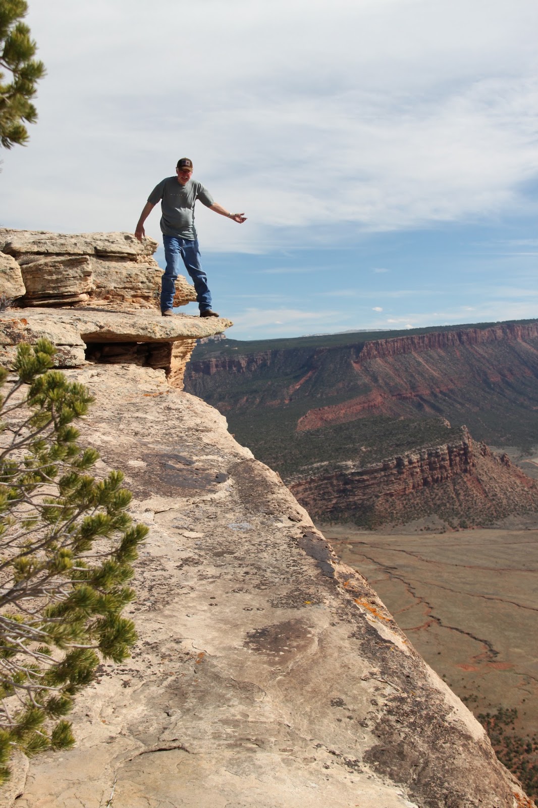 |
| Tom braved a perch on an overhanging rock |
But first, we traveled the dead end road to its conclusion. THIS road had some “interesting” obstacles that prompted us to discuss the difficulty of the return trip. Our speculation proved to be warranted as we struggled to climb the steep and rough obstacles on the return trip. Tom and I love trails like this.
Back at the first side road intersection, I built a cairn to mark the trail we were about to try. By now, both vehicles were showing an alarming lack of fuel, so concern for following this road was questioned. If it didn’t take us out to the Entrada Road, it could become a long walk out. Tom’s GPS and my nose made me confident we would be rewarded. Twice we came to places that put those guiding references in question. One place, the GPS showed us at a fork that wasn’t visible from the position we looked for it. After a turn in the trail, that intersection finally revealed.
The next alarm rang at a wash crossing. The wash was a wide slickrock bottom with no sign of a trail in sight. Going down the wash looked to end in a waterfall in the distance so my nose pointed me across and uphill where we found the trail resumed. A while later, we crossed over the downfall branches mentioned earlier and onto the Entrada Road.
 |
| Tom on a series of ledges |
During this descent, we had been hearing CB chatter from the other group. We learned that Roy had a disabled Side-by-Side in tow and they were struggling to get back to the Entrada Road. We reconnected with the last of the group at that intersection finding trip leader Todd working on his transfer case linkage. At the trailhead, low range is no longer necessary, but his would not shift. Soon he had shifted from low to high range and down the road we went.
Tom and I had decided to cross the Delores River and go home by way of the back roads. At the crossing, we re-evaluated that notion. The sandbar normally visible on the east side of the river was well submerged in raging swift water. The docile river I had crossed only a week before was now at least 2 feet deeper and really rolling along. We would be returning by way of I-70.
 |
| Looking down the Colorado River Valley from "Top II" |
Upon reaching the Fruita exit, we turned off looking for a place for a late dinner. The Mexican place had a parking lot full, so we went on to the Rib City restaurant. Surprise, club President Jeff, and friends were there already eating, but we joined them anyway.
It was a great day on the trails of eastern Utah. It was also a reminder of why I live by Yogi Berra’s quip; “When you come to a fork in the road, take it!” You just never know what you may find.
Finding a Jeep trail of this quality and length is extremely rare in this time of trail closures. Cherish the trails we have left and FIGHT for access to them. As the Director of Environmental Affairs for the United Four Wheel Drive Associations, I spend about 30 to 60 hours a week researching and writing comments to the BLM and USFS trying to make them understand what each trail means to motorized recreation. For over 40-years, this has been a passionate effort for me. One more trail closure is one too many.
On the positive side, moving to Grand Junction has been a blessing like being given the world. The passion for exploration and the area's history of mining have provided us with many trails to enjoy. Since 2007, I have found and REopened five trails closed by Mother Nature. Two of them required help and the others I did alone. REopening just one trail is a thrill that most will never experience.
We are presently working to OPEN one trail segment on the Tabeguache Trail. The trail has been built, but the access to it is still in limbo after over 30-years of efforts by the Grand Mesa Jeep Club.
We have proposed several extreme Jeep trails and another "connector" trail to land management as well. This is what an active club with superior leadership can do. Building excellent working relationships with land management DOES work. It takes immense time and patience to make it work, but the payoff is definitely worth the effort.
So, when YOU come to a fork in the road, take it!! It may become YOUR favorite trail.
Copyright Happy Trails 4wd, 2017. All rights reserved.
 |
| Fisher Tower is the dark red tower next to the "V" notch. The terminus of the Top of the World trail is above the four short spires. |
 |
| The ranch in the upper Fisher Valley |
 |
| Looking over Onion Creek canyon. |
 |
| The Fisher Valley |
 |
| On the trail |